09/05/2025
profile
map
technical info
A mixed stage with a challenging finale that will reveal the team leaders’ condition right from the start. The approach heads inland from the coast, tackling the area around the capital via the Gracen pass, followed by a final circuit featuring a double ascent of Surrel with gradients in the double digits in the first part.
10/05/2025
profile
map
technical info
A time trial for specialists. Predictably high averages are expected given the configuration of this very fast course, punctuated only by a few U-turns or sharp corners. In the city centre, there’s a short climb before entering the final stretch.
11/05/2025
profile
map
technical info
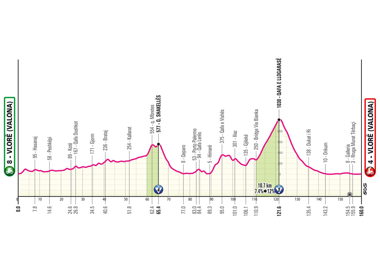
A mixed stage featuring numerous ups and downs in the first three-quarters, along with two significant climbs with occasionally steep gradients. The second climb is over 10 km and above 1000 m. A long descent leads to Valona for a likely reduced sprint finish.
13/05/2025
profile
map
technical info
A sprinter-friendly stage with only a small climb at the start, followed by long, straight, high-speed roads interrupted only by the towns along the route. The final circuit is perfect for a bunch sprint.
14/05/2025
profile
map
technical info
The third stage for fast wheels who, however, will need to earn their sprint. In the past, sprints in Matera have been tight but always suited pure sprinters. The first part is fast along the Metaponto coast, then the peloton heads inland, tackling several short climbs leading to a long descent into the final straight.
15/05/2025
profile
map
technical info
A bunch sprint finish in Naples. This long stage traverses the north of Basilicata and Irpinia before reaching the Naples area, skirting Mount Vesuvius and then heading directly toward the Gulf and via Caracciolo.
16/05/2025
profile
map
technical info
This tough Apennine stage features the first uphill finish. The race tackles Roccaraso at the start, and after a long descent from Pian delle Cinque Miglia to Sulmona, it climbs Monte Urano and Vado della Forcella on Monte Sirente. The various ups and downs culminate in the final ascent from Tagliacozzo to Marsia, with the last 3 km featuring persistent double-digit gradients.
17/05/2025
profile
map
technical info
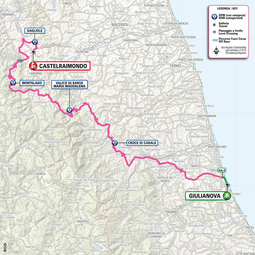
A major Apennine stage with significant elevation gain (3700 m) and hardly any flat ground to play with. The route takes on roads often featured in the Tirreno-Adriatico, climbing in sequence Sassotetto (Santa Maria Maddalena pass), Montelago, Castel Santa Maria, and Gagliole. Expect an arrival of select groups.
18/05/2025
profile
map
technical info
A gravel stage that features much of the Strade Bianche roads in the finale. After approaching the Senese region, riders will tackle five gravel sections made famous by the Strade Bianche, totaling 29.5 km. They are: Pieve a Salti (8.0 km), Serravalle (9.3 km), San Martino in Grania (9.3 km), Monteaperti (0.6 km), and Colle Pinzuto (2.3 km). The entrance to Siena is from Fontebranda, leading to the Muro di Santa Caterina before entering Piazza del Campo.
20/05/2025
profile
map
technical info
A very fast time trial with a small intermediate climb (not classified as a KOM). The route roughly retraces the 1977 time trial won by Knudsen. Starting with a half lap of the Lucca walls (as in the 1984 prologue), it then heads towards Pisa via the Foro di San Giuliano and San Giuliano Terme. Riders follow the Medicean aqueduct to reach River Arno and finally finish next to the Leaning Tower in Piazza dei Miracoli.
21/05/2025
profile
map
technical info
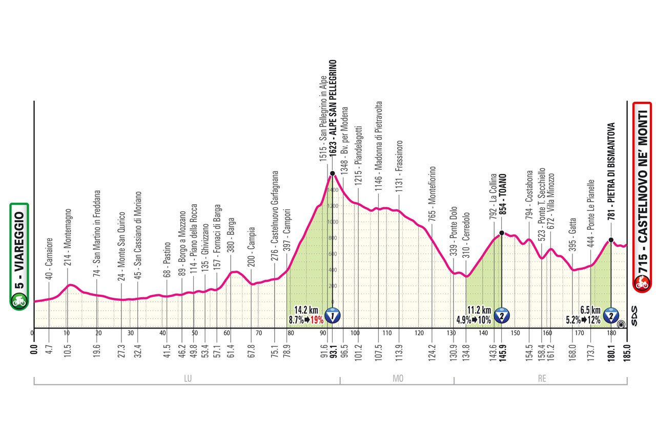
A tough stage from halfway onwards. From Viareggio, the route ascends the Garfagnana, passing through Barga and Castelnuovo. After 25 years since its last appearance, riders will tackle San Pellegrino in Alpe with gradients hitting 20%. A long, winding descent through the woods of the Apennines leads to Cerredolo, where the climb to Toano begins, and finally, with 10 km to go, riders will tackle the ascent of the Pietra di Bismantova, a symbol of the arrival city.
22/05/2025
profile
map
technical info
A likely bunch sprint in the heart of the Po Valley. The stage starts with a circuit along the roads of the Matildic Castles before opening up in the plains. After an initial passage through Viadana, the stage features a circuit touching the town of Sabbioneta.
23/05/2025
profile
map
technical info
A stage that is (almost) perfectly flat up until the first passage at the finish line. From Rovigo to Vicenza, the route presents only a brief interruption in Castelnuovo, in the Euganean Hills. Once in Vicenza, after the first pass on Monte Berico, the riders will complete two laps of a challenging circuit featuring via Pilla and Monte Berico itself, culminating on the iconic wall where Gilbert triumphed in 2015.
24/05/2025
profile
map
technical info
A flat stage through the Veneto plain and southern Friuli. After Cormons, the riders face the ups and downs of Collio (Brda in Slovenian) and two laps of the circuit linking the two cities of Nova Gorica and Gorizia, with the Saver peak serving as the final bump before a fairly large sprint.
25/05/2025
profile
map
technical info
A classic “pre-Alpine” mountain stage featuring some “forgotten” climbs. A tribute to Ottavio Bottecchia will be held in the centenary year of his second Tour de France victory. From Romano d’Ezzelino, riders ascend Monte Grappa via the historic Strada Cadorna (which has only been tackled downhill in the last 15 years). A descent to Feltre is followed by a climb to the Altopiano dei Sette Comuni from Enego, culminating in the finish in Asiago.
27/05/2025
profile
map
technical info
A very tough stage with the highest elevation gain of the Giro (almost 5000 m), certainly a decisive one for the overall classification. After departing from Villa Contarini in Piazzola sul Brenta, riders enter Trentino from the Val d’Astico via the Fricca pass, where there won’t be a meter of respite, stringing together a sequence of climbs and descents including La Fricca, Candriai (the first half of Bondone), Vigo Cavedine, the grueling Santa Barbara (or Monte Velo), and the final ascent to San Valentino from Brentonico.
28/05/2025
profile
map
technical info
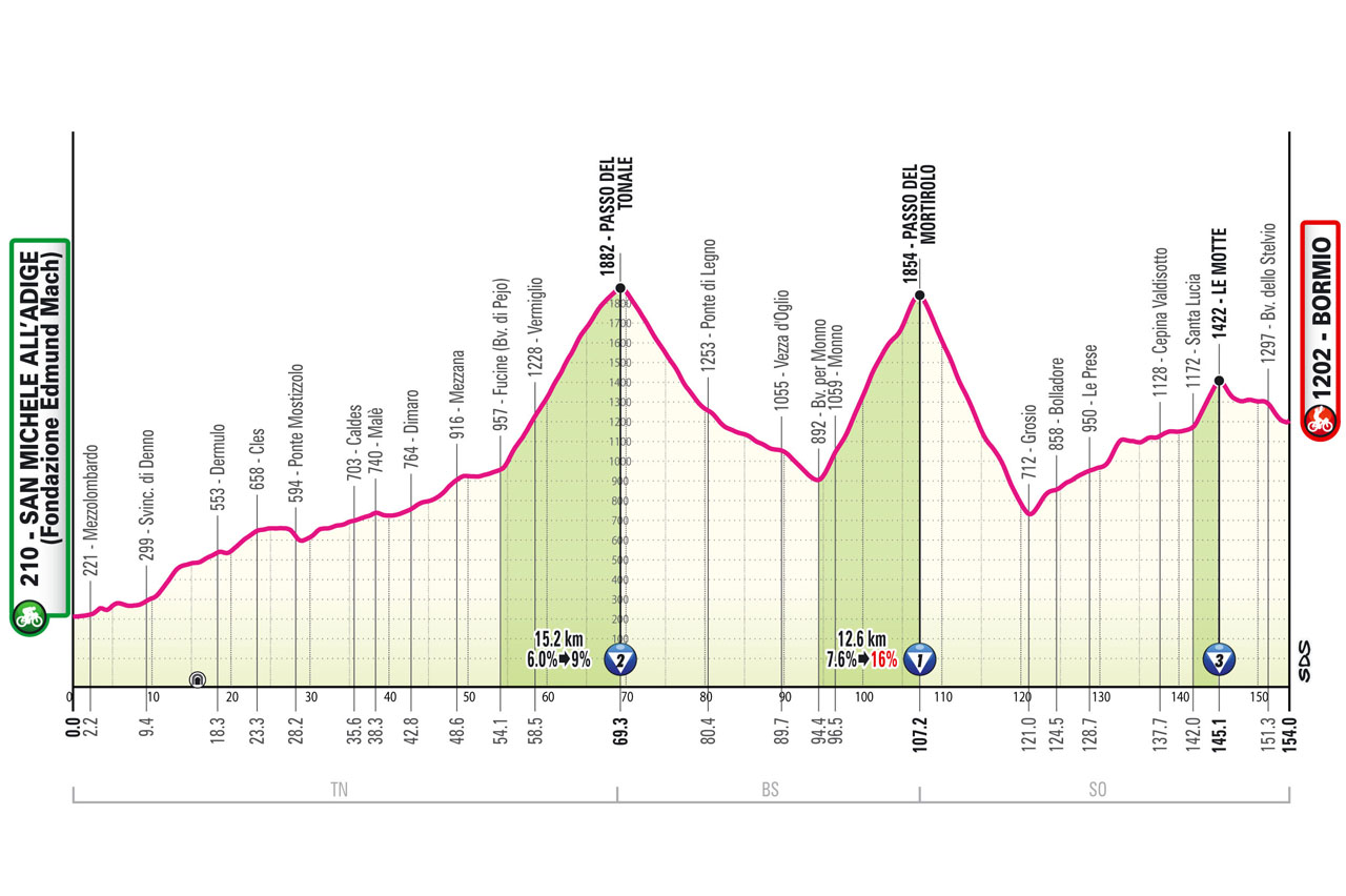
A stage for breakaways and actions from afar. The main climbs, including Mortirolo, are quite far from the finish, but the finale is constantly uphill, albeit not excessively steep, such that a small lapse could result in significant gaps.
29/05/2025
profile
map
technical info
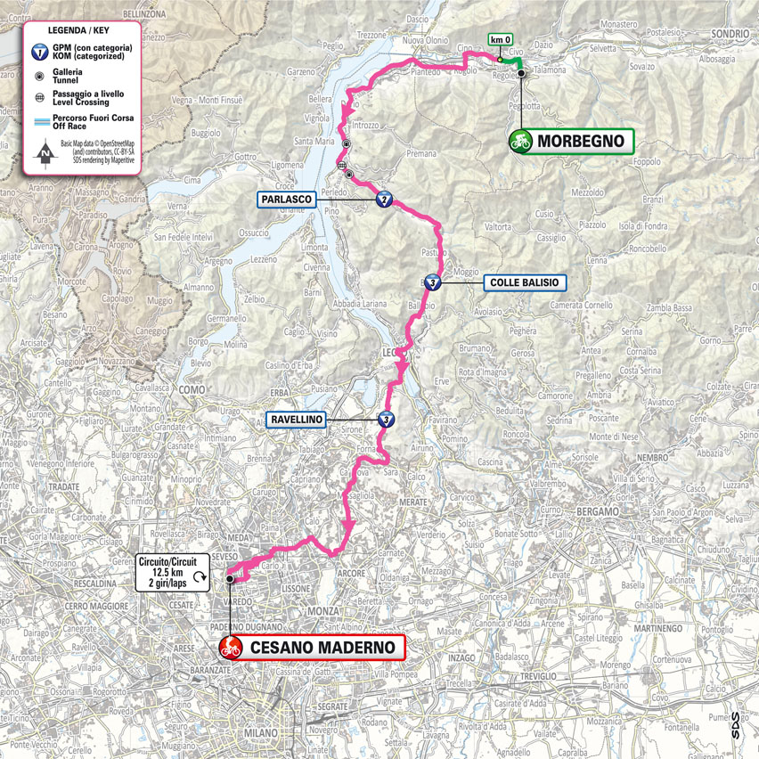
A “quiet” stage likely to feature a final sprint, the last before Rome. After a flat start and the rideable climb of Colle Balisio, riders will tackle some must-do climbs for amateurs in the area north of Milan, such as Colle Brianza (summit at Ravellino) and Sirtori. The last 50 km are perfectly flat, with a fast final circuit of 12.5 km to be covered twice.
30/05/2025
profile
map
technical info
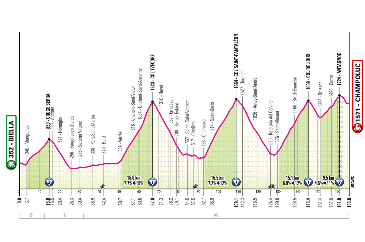
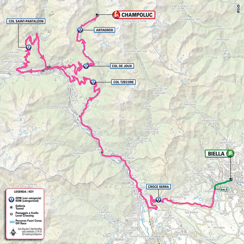
A high mountain stage. After climbing Serra from Biella and traversing a short stretch of the Dora Baltea valley, three successive climbs of 16 km each with notable gradients are tackled: Col Tzecore (up to 15%), Col Saint-Pantaléon, and Col de Joux. A descent leads to Brusson, followed by the final climb that ends 5 km from the finish in Champoluc (Ayas).
31/05/2025
profile
map
technical info
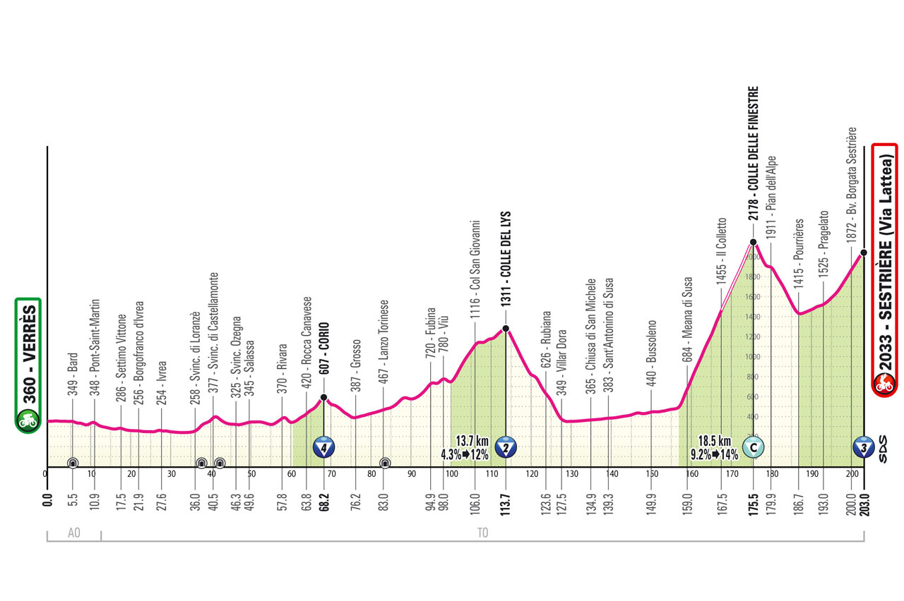
A decisive stage of the Giro if the gaps are not particularly large. The route retraces much of Chris Froome’s solo ride at the Giro 2018. The approach from Valle d’Aosta to the Lanzo valleys includes the ascent of Colle del Lys as an appetizer to the Colle delle Finestre, the Cima Coppi of this edition with its 8 km of 9% gravel. After a brief descent, the final ascent to Sestriere awaits.
01/06/2025
profile
map
technical info
A ceremonial final stage similar to those in past years, featuring an initial back-and-forth to the coastline followed by several laps of the city circuit.
Durazzo (Durrës) – Tirana (Tiranë)
profile
map
technical info
A mixed stage with a challenging finale that will reveal the team leaders’ condition right from the start. The approach heads inland from the coast, tackling the area around the capital via the Gracen pass, followed by a final circuit featuring a double ascent of Surrel with gradients in the double digits in the first part.
Tirana (Tiranë) – Tirana (Tiranë) TUDOR ITT
profile
map
technical info
A time trial for specialists. Predictably high averages are expected given the configuration of this very fast course, punctuated only by a few U-turns or sharp corners. In the city centre, there’s a short climb before entering the final stretch.
Valona (Vlorë) – Valona (Vlorë)
profile
map
technical info
A mixed stage featuring numerous ups and downs in the first three-quarters, along with two significant climbs with occasionally steep gradients. The second climb is over 10 km and above 1000 m. A long descent leads to Valona for a likely reduced sprint finish.
Alberobello (Pietramadre) – Lecce
profile
map
technical info
A sprinter-friendly stage with only a small climb at the start, followed by long, straight, high-speed roads interrupted only by the towns along the route. The final circuit is perfect for a bunch sprint.
Ceglie Messapica – Matera
profile
map
technical info
The third stage for fast wheels who, however, will need to earn their sprint. In the past, sprints in Matera have been tight but always suited pure sprinters. The first part is fast along the Metaponto coast, then the peloton heads inland, tackling several short climbs leading to a long descent into the final straight.
Potenza – Napoli
profile
map
technical info
A bunch sprint finish in Naples. This long stage traverses the north of Basilicata and Irpinia before reaching the Naples area, skirting Mount Vesuvius and then heading directly toward the Gulf and via Caracciolo.
Castel di Sangro – Tagliacozzo
profile
map
technical info
This tough Apennine stage features the first uphill finish. The race tackles Roccaraso at the start, and after a long descent from Pian delle Cinque Miglia to Sulmona, it climbs Monte Urano and Vado della Forcella on Monte Sirente. The various ups and downs culminate in the final ascent from Tagliacozzo to Marsia, with the last 3 km featuring persistent double-digit gradients.
Giulianova – Castelraimondo
profile
map
technical info
A major Apennine stage with significant elevation gain (3700 m) and hardly any flat ground to play with. The route takes on roads often featured in the Tirreno-Adriatico, climbing in sequence Sassotetto (Santa Maria Maddalena pass), Montelago, Castel Santa Maria, and Gagliole. Expect an arrival of select groups.
Gubbio – Siena
profile
map
technical info
A gravel stage that features much of the Strade Bianche roads in the finale. After approaching the Senese region, riders will tackle five gravel sections made famous by the Strade Bianche, totaling 29.5 km. They are: Pieve a Salti (8.0 km), Serravalle (9.3 km), San Martino in Grania (9.3 km), Monteaperti (0.6 km), and Colle Pinzuto (2.3 km). The entrance to Siena is from Fontebranda, leading to the Muro di Santa Caterina before entering Piazza del Campo.
Lucca – Pisa TUDOR ITT
profile
map
technical info
A very fast time trial with a small intermediate climb (not classified as a KOM). The route roughly retraces the 1977 time trial won by Knudsen. Starting with a half lap of the Lucca walls (as in the 1984 prologue), it then heads towards Pisa via the Foro di San Giuliano and San Giuliano Terme. Riders follow the Medicean aqueduct to reach River Arno and finally finish next to the Leaning Tower in Piazza dei Miracoli.
Viareggio – Castelnovo ne' Monti
profile
map
technical info
A tough stage from halfway onwards. From Viareggio, the route ascends the Garfagnana, passing through Barga and Castelnuovo. After 25 years since its last appearance, riders will tackle San Pellegrino in Alpe with gradients hitting 20%. A long, winding descent through the woods of the Apennines leads to Cerredolo, where the climb to Toano begins, and finally, with 10 km to go, riders will tackle the ascent of the Pietra di Bismantova, a symbol of the arrival city.
Modena – Viadana (Oglio-Po)
profile
map
technical info
A likely bunch sprint in the heart of the Po Valley. The stage starts with a circuit along the roads of the Matildic Castles before opening up in the plains. After an initial passage through Viadana, the stage features a circuit touching the town of Sabbioneta.
Rovigo – Vicenza
profile
map
technical info
A stage that is (almost) perfectly flat up until the first passage at the finish line. From Rovigo to Vicenza, the route presents only a brief interruption in Castelnuovo, in the Euganean Hills. Once in Vicenza, after the first pass on Monte Berico, the riders will complete two laps of a challenging circuit featuring via Pilla and Monte Berico itself, culminating on the iconic wall where Gilbert triumphed in 2015.
Treviso – Nova Gorica/Gorizia
profile
map
technical info
A flat stage through the Veneto plain and southern Friuli. After Cormons, the riders face the ups and downs of Collio (Brda in Slovenian) and two laps of the circuit linking the two cities of Nova Gorica and Gorizia, with the Saver peak serving as the final bump before a fairly large sprint.
Fiume Veneto – Asiago
profile
map
technical info
A classic “pre-Alpine” mountain stage featuring some “forgotten” climbs. A tribute to Ottavio Bottecchia will be held in the centenary year of his second Tour de France victory. From Romano d’Ezzelino, riders ascend Monte Grappa via the historic Strada Cadorna (which has only been tackled downhill in the last 15 years). A descent to Feltre is followed by a climb to the Altopiano dei Sette Comuni from Enego, culminating in the finish in Asiago.
Piazzola sul Brenta – San Valentino (Brentonico)
profile
map
technical info
A very tough stage with the highest elevation gain of the Giro (almost 5000 m), certainly a decisive one for the overall classification. After departing from Villa Contarini in Piazzola sul Brenta, riders enter Trentino from the Val d’Astico via the Fricca pass, where there won’t be a meter of respite, stringing together a sequence of climbs and descents including La Fricca, Candriai (the first half of Bondone), Vigo Cavedine, the grueling Santa Barbara (or Monte Velo), and the final ascent to San Valentino from Brentonico.
San Michele all'Adige (Fondazione Edmund Mach) – Bormio
profile
map
technical info
A stage for breakaways and actions from afar. The main climbs, including Mortirolo, are quite far from the finish, but the finale is constantly uphill, albeit not excessively steep, such that a small lapse could result in significant gaps.
Morbegno – Cesano Maderno
profile
map
technical info
A “quiet” stage likely to feature a final sprint, the last before Rome. After a flat start and the rideable climb of Colle Balisio, riders will tackle some must-do climbs for amateurs in the area north of Milan, such as Colle Brianza (summit at Ravellino) and Sirtori. The last 50 km are perfectly flat, with a fast final circuit of 12.5 km to be covered twice.
Biella – Champoluc
profile
map
technical info
A high mountain stage. After climbing Serra from Biella and traversing a short stretch of the Dora Baltea valley, three successive climbs of 16 km each with notable gradients are tackled: Col Tzecore (up to 15%), Col Saint-Pantaléon, and Col de Joux. A descent leads to Brusson, followed by the final climb that ends 5 km from the finish in Champoluc (Ayas).
Verrès – Sestrière (Vialattea)
profile
map
technical info
A decisive stage of the Giro if the gaps are not particularly large. The route retraces much of Chris Froome’s solo ride at the Giro 2018. The approach from Valle d’Aosta to the Lanzo valleys includes the ascent of Colle del Lys as an appetizer to the Colle delle Finestre, the Cima Coppi of this edition with its 8 km of 9% gravel. After a brief descent, the final ascent to Sestriere awaits.
Roma – Roma
profile
map
technical info
A ceremonial final stage similar to those in past years, featuring an initial back-and-forth to the coastline followed by several laps of the city circuit.


